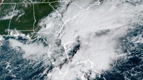
(Tuesday 4:30 p.m.) Haywood County declared a state of emergency as the remnants of Tropical Depression Ida pass through the region. The county also issued a voluntary evacuation order for the areas still rebuilding from the last floods along the Pigeon River: Cruso, Bethel, Lake Logan, Center Pigeon, Canton, and Clyde.
Emergency Services spokesperson Allison Richmond says they’re preparing more than usual because local roads, bridges and infrastructure haven’t had a chance to recover from the last storm. “We don’t have the same information that we normally would going in on how the river will react to flooding," Richmond told BPR. "So if we get a lot of rain in higher elevations and it starts coming downstream, we want to make sure that everybody in that path has a chance to make an informed decision beforehand.”
Rainfall is forecast to be heaviest in the evening and overnight hours. A flood advisory from the National Weather Service is in effect until 6:30 Tuesday evening for Clay and Cherokee Counties in North Carolina. The NWS says Andrews, Brasstown, Hayesville, Hothouse, and Murphy can expect minor flooding, which could turn into flash flooding depending on conditions.
(Tuesday 11:45 a.m.) Schools in Haywood County will dismiss early on Tuesday ahead of rains from Tropical Depression Ida, which will begin to fall in earnest Western North Carolina later this afternoon.
Schools will dismiss at 1 p.m. Tuesday. Rains in the region are expected to be heaviest between 6 p.m. Tuesday and 6 a.m. Wednesday. Areas in southern Macon, Jackson, and Transylvania Counties are forecast to see the most rainfall, up to six inches. Emergency authorities in Macon County in particular are concerned Highlands and Scaly Mountain, as well as winds that could down utility poles overnight.
A flash flood watch is in effect until Wednesday afternoon for the entire region. A wind advisory is also in effect until 8 a.m. Wednesday for areas above 3500 feet in elevation in Graham, Haywood, Jackson, Madison, and Swain Counties. The National Weather Service says those areas could see winds gusts of up to 45 m.p.h.
(Monday 3:30 p.m.) Still reeling and cleaning up from the floods caused by the remnants of Tropical Storm Fred two weeks ago, rain is expected Tuesday in Western North Carolina from the remnants of Hurricane Ida.A flash flood watch issued by the National Weather Service is in effect Tuesday morning through Wednesday afternoon for the region. Rainfall forecasts for the region vary anywhere from 1 to 6 six inches starting Tuesday. The heaviest hours for rainfall in the forecast are from 6 p.m. to midnight Tuesday.
Areas of Jackson, Macon, and Transylvania Counties that border Georgia and South Carolina are expected to get the heaviest rainfall totals from Ida. Emergency services in Macon County expect the Highlands and Scaly Mountain areas to be heaviest hit by the rain. In a press release, the county says Ida is not expected to cause any fuel disruptions as has been the case in the past with storms that hit the Gulf region.
Two weeks ago, some parts of Western North Carolina saw as much as 20 inches of rain from the remnants of Tropical Storm Fred. Haywood County saw the worst of the flooding, in particular Canton and Cruso along the Pigeon River and its tributaries. Six people were killed, and flood damages were initially estimated to be in the hundreds of millions of dollars. North Carolina Governor Roy Cooper formally requested a federal disaster declaration from the federal government on Friday, which if granted would allow the region to receive millions in federal aid.
This story will be upated as events necessitate
Copyright 2021 BPR News. To see more, visit BPR News.


