Updated 5 p.m.
Forecasters say Hurricane Dorian is expected to slowly weaken as it travels near and along the coasts of South and North Carolina.
In its 5 p.m. advisory, the National Hurricane Center says Dorian has weakened slightly and remains a Category 2 storm with maximum sustained winds of 105 mph.
Its eye is located about 45 miles southeast of Myrtle Beach, South Carolina, and is moving northeast at about 10 mph.
Forecasters expect Dorian's eye to pass near or over parts of the North Carolina coast within the next 12 to 24 hours.
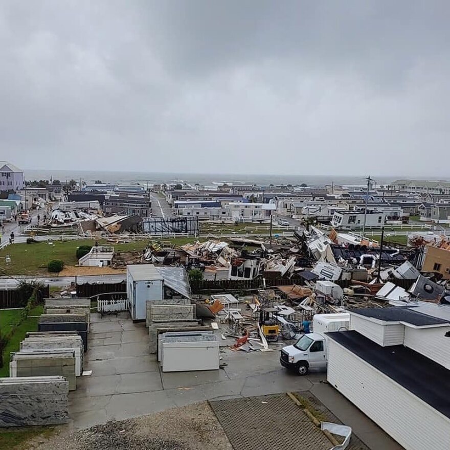
Tornado Hits Emerald Isle
Emerald Isle was hit with at least one tornado that spun out of Hurricane Dorian, causing damage to residences and mobile homes in the coastal North Carolina town.
The National Weather Service published several pictures that showed the damage, as well as one that captured the tornado near the coast.
"Last minute efforts should solely focus on protecting life. The area remains subject to considerable wind damage," according to a National Weather Service notice.
Dorian's maximum sustained winds have dropped slightly to 110 mph, making it once again a Category 2 hurricane. That's still strong enough to cause damage along the coast of the Carolinas, where the storm is now close enough for hurricane-force winds to hit land.
Forecasters say Dorian's center at 11 a.m. was about 50 miles east-southeast of Charleston, South Carolina, still moving north off the coast at about 8 mph. Hurricane-force winds extend outward up to 60 miles from the center and tropical-storm-force winds extend outward up to 195 miles.
The National Hurricane Center says large and destructive waves up to 8 feet high could be seen in Myrtle Beach if peak surge happens during high tide.

Updated 11 a.m.
Hurricane Dorian continued its slow move up the Atlantic coast, as the earliers effects began to be felt in parts of North Carolina.
Storm surge continued to be the biggest risk to life and property, accordin to the National Hurricane Center. Flash floods were also likely in the eastern third of North Carolina.
Dorian had slowed slightly in the run up to the Hurricane Center's 11 a.m. update, but forecasters expectdd it to pick up speed again as it turns northweast and runs along the South Carolina toward the North Carolina coast.
"The center of Dorian is expected to move very near or over the coastline of the Carolinas and the southern Mid-Atlantic states. Residents of these areas should already be prepared for damaging winds, life-threatening storm surges, and flooding rains," according to the Hurricane Center.

Update 8 a.m.
As Hurricane Dorian blows off the coast of the Carolinas, forecasters are predicting high storm surges and drenching rains that could trigger flooding and unleash environmental hazards in areas still recovering from last year's Hurricane Florence.
The National Weather Service said hurricane warnings were in effect Thursday for the Carolina coasts up to Virginia, with a "potentially life threatening storm surge" of up to 8 feet (2.4 meters) around the North Carolina-South Carolina line. Coupled with high tide, the storm's arrival Thursday is expected to push water up the mouths of coastal rivers, causing low-lying areas to flood. There could also be up to a foot of rainfall across much of Eastern North Carolina, raising concerns of flash flooding well inland.
Some areas in the region expected to be affected by Dorian are still rebuilding from Florence, which caused widespread damage in September 2018 that included scores of flooded hog and chicken farms, inundated sewage treatment plants and breached dam at a power plant near a coal ash landfill.
Dorian's eye was skirting the coast, potentially making landfall before brushing past Cape Hatteras. It was shaping up to be a more glancing blow than Florence, which slowly moved inland a year ago, dumping record-shattering rains of more than 2 feet (0.6 meters) in places.
Jen Kendrick, spokeswoman for the N.C. Pork Council, said the members of her organization are well positioned to weather Dorian after a relatively dry summer.
"Farmers in North Carolina have seen about 20 hurricanes in the past two decades and have learned much about preparation and readiness," Kendrick said.
Those preparations include relocating animals from flood-prone farms, stocking up on livestock feed in case roads are flooded and filling up the fuel tanks for the generators used to keep pumps going in the event of power outages.
Duke Energy said Wednesday that it had completed extensive repairs to the dam that breached during Florence at the L.V. Sutton Power Station near Wilmington, North Carolina. The company said it had also competed excavation of a large coal ash dump that flooded last year, removing the gray ash containing toxic heavy metals to a landfill on higher ground covered with an artificial turf cap designed to repeal rainwater.
Though part of that landfill is still under construction, Duke spokeswoman Paige Sheehan said they were not expecting any problems from Dorian at the Sutton site.
"We feel very well prepared for this storm," Sheehan said.
Duke also operates the Brunswick Nuclear Plant near the mouth of the Cape Fear River. The company said it will safely shut down the plant's twin nuclear reactors at least two hours prior to the arrival of any hurricane force winds.


