Updated at 5:30 a.m. ET
The National Hurricane Center says Hurricane Maria is an extremely dangerous storm. It was a Category 5 storm when it hit the island of Dominica. Later it was downgraded to a Category 4 hurricane. But a short time ago, forecasters says Maria had regained the strength of a Category 5 hurricane.
Updated at 3:15 a.m. ET Tuesday

Hurricane Maria has weakened slightly after moving over the Caribbean island of Dominica. The National Hurricane Center downgraded Maria to a category 4 storm, with maximum sustained winds of 155 mph.
Updated at 11:10 p.m. ET
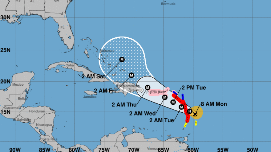
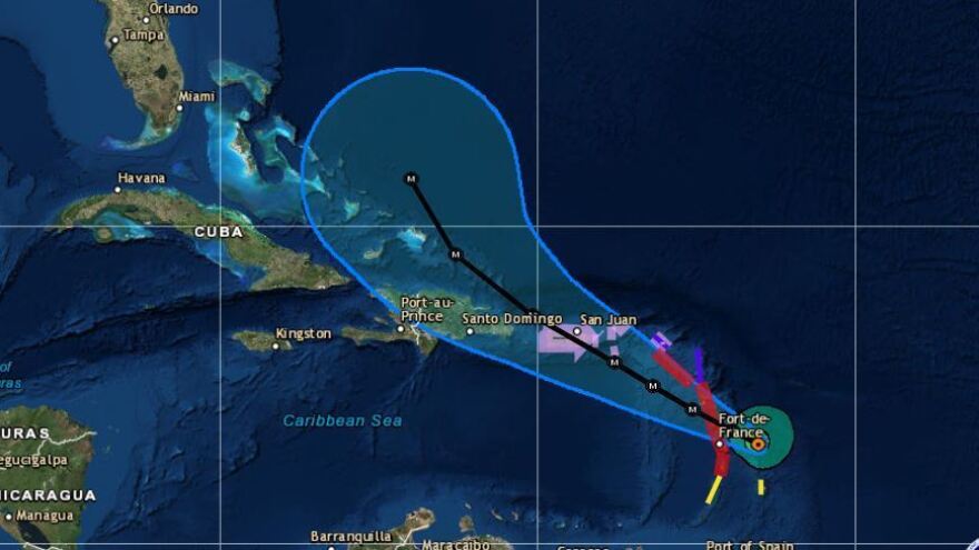
Hurricane Maria is now an "extremely dangerous" Category 5 storm hitting the Leeward Islands on the edge of the Caribbean Sea on Monday night, according to the National Hurricane Center. That means the storm is striking areas that are still coping with the devastation brought by Hurricane Irma two weeks ago. Forecasts call for it to pass straight over Puerto Rico on Wednesday.
Maria's sustained maximum winds are currently at 160 mph. The eye of the storm came ashore 9:15 p.m. ET Monday at Dominica, heading west-northwest at around 9 mph.
Roosevelt Skerritt, Dominica's prime minister, said on Facebook that his roof had been ripped off and his house was flooding but later posted that he'd been rescued. The National Hurricane Center also cites ham radio broadcasts saying significant damage to structures has occurred in Dominica.
A hurricane warning — meaning hurricane conditions are expected to strike — has been issued for Guadeloupe, Dominica, St. Kitts and Nevis and Montserrat, as well as the neighboring British and U.S. Virgin Islands, Puerto Rico, Culebra and Vieques.
Late Monday, President Trump issued emergency declarations for Puerto Rico and the U.S. Virgin Islands ordering "federal assistance to supplement the response efforts of the territory."

A tropical storm warning is in effect for Antigua and Barbuda, Saba, St. Eustatius, St. Martin, Anguilla, St. Lucia and Martinique.
An Air Force Reserve Unit Hurricane Hunter aircraft flew on a route in and around Maria Monday morning to investigate the storm's development, the hurricane center said.
Unlike Irma, which took a relatively flat westward angle as it raked Barbuda, St. Martin, Cuba and other islands and stormed toward the Florida Keys, Maria is expected to take a sharper northwest tack, passing east of the Turks and Caicos as it heads toward the Bahamas.
Maria puts many of those same areas at risk — including the Virgin Islands, parts of which were hit by Irma's eyewall before that storm veered north. Maria's different approach also means that Puerto Rico and other islands that suffered only glancing blows from Irma could now be directly confronted with hurricane conditions.
The National Hurricane Center notes that "some fluctuations are expected over the next day or two, but Maria is forecast to remain an extremely dangerous hurricane while it approaches the U.S. Virgin Islands and Puerto Rico."
"The government is prepared," Puerto Rico Gov. Ricardo Rosselló said via Facebook, "and we ask of the citizenship preparation, attention, and action."
On the Saffir-Simpson wind scale, a major hurricane designates Category 3 storms and higher — hurricanes with sustained winds of at least 111 mph.
Maria fits that description and is expected to remain a major hurricane through the weekend.
Maria doesn't have the historic size and strength of Irma, and its hurricane-force winds extend outward up to 30 miles — short of the 70 miles such winds extended from Irma's center. But the hurricane's storm surge and heavy rains could post grave threats, from triggering mudslides to frustrating relief and recovery efforts in places where thousands of buildings were heavily damaged by Irma.
Maria is expected to produce total rain accumulations of 10 to 15 inches in the central and southern Leeward Islands, the hurricane center says, "with isolated maximum amounts of 20 inches across the central and southern Leeward Islands, including Puerto Rico and the U.S. and British Virgin Islands, through Wednesday night."
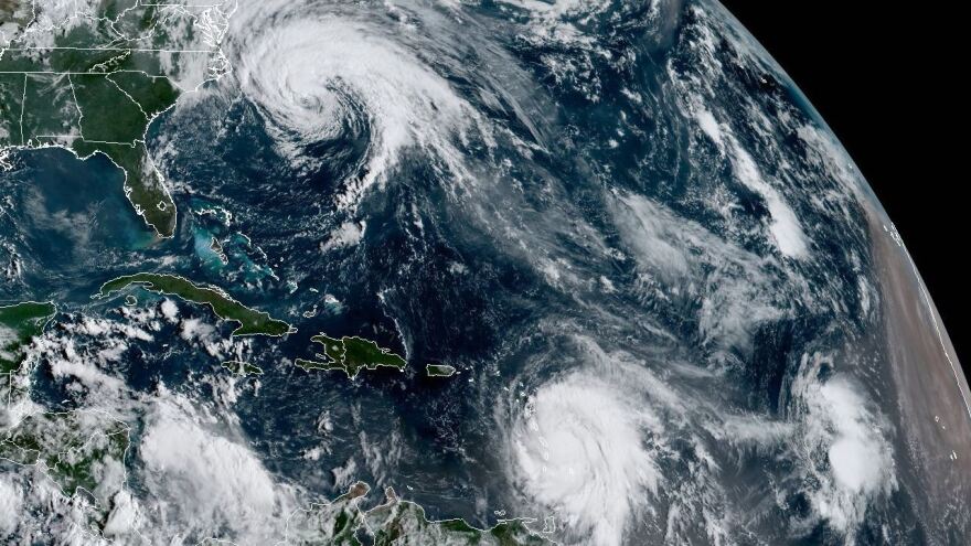
Hurricane Jose, which buzzed the Leeward Islands as it moved north and west in Irma's wake last week, has now weakened, with maximum sustained winds of 75 mph. Jose is currently about 235 miles east of Cape Hatteras, N.C., and is expected to remain off the East Coast.
After being stationary for a while Monday evening, Jose began moving northward again at 8 mph and "dangerous surf and rip currents are expected to continue along the east coast of the United States," says the National Hurricane Center. A tropical storm warning is in effect for areas from Watch Hill to Hull, Block Island, Martha's Vineyard and Nantucket.
The center points to the likelihood of "direct impacts" on New England, but adds that it would take only a slight deviation of the storm to increase the storm's effects along the coast from Delaware northward.
Copyright 2021 NPR. To see more, visit https://www.npr.org. 9(MDAxNzg0MDExMDEyMTYyMjc1MDE3NGVmMw004))


